Below you will find a list of abstracts presented by CBTH Researchers at the 2015
Gulf Coast Association of Geological Societies (GCAGS) meeting in Houston.
- TITLE:
Tectonostratigraphic Evolution of the Lower Magdalena Basin, Colombia: An Example of an Underfilled to Overfilled Forearc Basin
AUTHORS: Rocio Bernal Olaya, Paul Mann, and Alejandro Escalona
ABSTRACT: Previous studies along the Andean subduction zones of South America and other areas have shown forearc basins can develop over shallow-dipping subduction zones where subduction dips of approximately horizontal to 15°, alternating with more steeply-dipping (>30°) subduction zones along strike parallel distances of 400 to 1500 km. This study describes the Cenozoic structural and depositional history of the Lower Magdalena basin (LMB), which is the 42,000 km2 forearc basin overlying the zone of shallow subduction; the depth to the top of the slab ranges in depth from 30–90 km beneath the LMB. Using 7000 km of seismic reflection lines tied to 33 wells, we describe the initial Oligocene subsidence of the forearc basin along normal faults striking 70–110° that remained active until the Early Miocene. During this period the LMB was filled by 1–3 s TWT (~1500 m) of shallow marine and deep marine facies. During the Middle Miocene, the basin was filled by marine sediments deposited in water depths of 200 to 2600 m. An angular unconformity spanning the interval of 11 to 7 Ma marks an important uplift event of the Sinu belt accretionary prism that emerged as a forearc high at this time. The regional structure of the basin was as a broad syncline that affected older units than the Early Miocene. After the Late Miocene–Pliocene, the forearc high continues to elevate and separate the LMB from the outer Sinu prism. LMB overfills with sediments of shallow marine facies and spills offshore into the proto-delta of the Magdalena fan; these spilled sediments lead to rapid tectonic accretion and growth of the inner and outer Sinu accretionary prism from 5 Ma to recent times. During the period of Oligocene to Early Miocene, different structural styles and magmatic intrusions suggest that the Caribbean plate was subducting at an angle greater than 30°, and that dip decreased to the modern values of 4–8° during the Late Miocene. Comparison of the segmented dip of the ~400 km long subducting Caribbean slab, is consistent with the upper, ~220 km long, shallow-dipping part subducting at rates of 20 mm/yr from 11 Ma (i.e., late Middle Miocene) to recent. We propose that this change from the steeper to shallower-dipping slab in the Middle Miocene led to: (1) increasing elevation of the forearc high of the LMB; (2) the synclinal structure of the LMB; and (3) the possible elevation of the entire LMB as it changed from deepwater marine environments to shallow-water marine and fluvial environments after 11 Ma.
- TITLE:
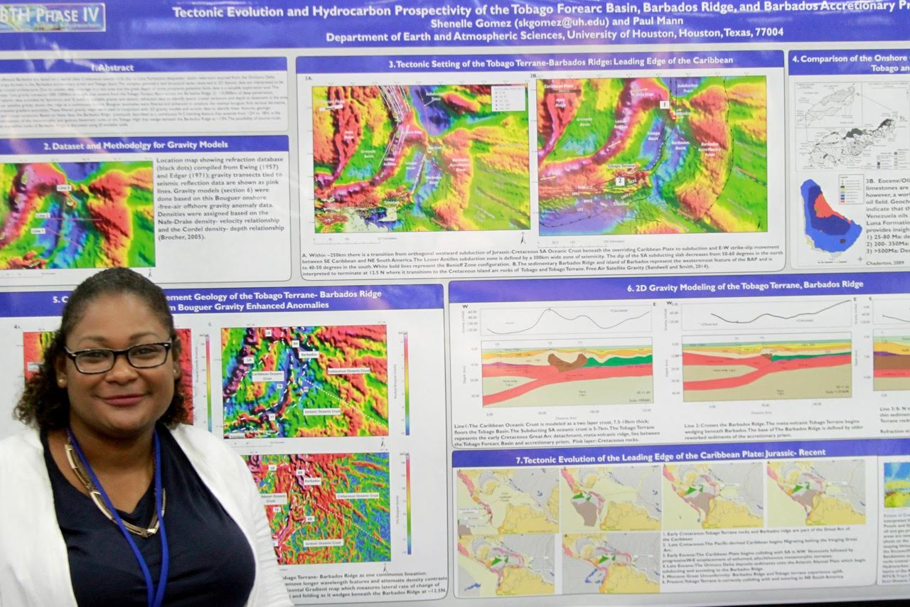
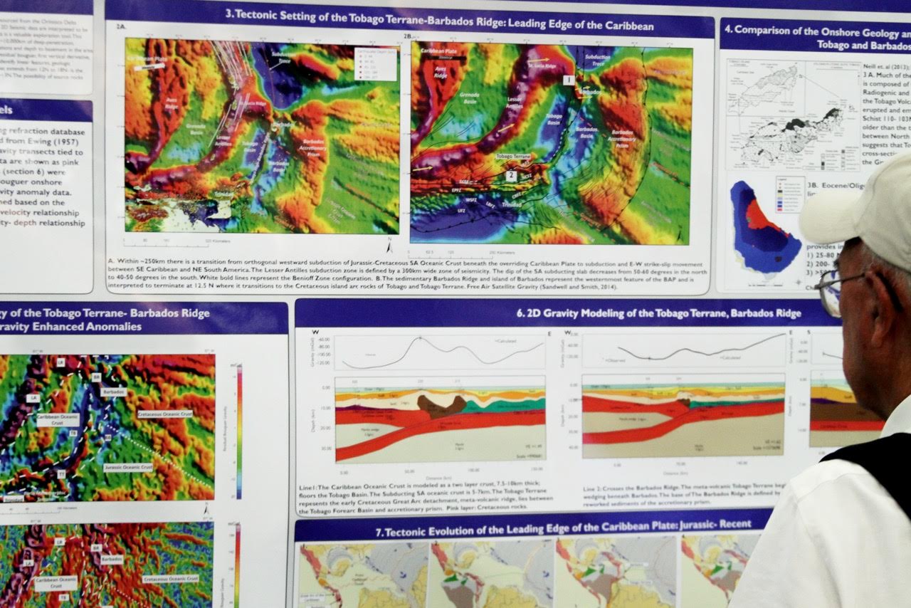
Tectonic Evolution and Hydrocarbon Prospectivity of the Tobago Forearc Basin, Barbados Ridge, and Barbados Accretionary Prism
AUTHORS: Shenelle Gomez, Paul Mann, and Bryan Ott
ABSTRACT: This study utilizes 10,000 km of modern, high-resolution, deep-penetration 2D seismic data provided by the oil industry to define the tectonic evolution and hydrocarbon prospectivity of the Lesser Antilles subduction zone in the Barbados and Trinidad maritime zones. This zone includes the following tectonic and basinal components: (1) Paleogene Tobago basin, formed as a forearc basin in front of the Lesser Antilles volcanic arc; (2) Barbados submarine ridge and island of Barbados, that represents the Eocene Barbados prism accreted to the front of the Lesser Antilles volcanic arc; and (3) the Late Miocene inner forearc deformation belt (IFDB), a 400-km-long and 50- to 70-km-wide zone of westward-verging folds and thrusts that formed as a result of ongoing convergence between the Tobago Basin and Barbados ridge.
Limited production of oil and gas on the island of Barbados confirms the presence of a working petroleum system consisting of a continentally-derived, quartz-rich, turbiditic sandstone reservoir of the Eocene Scotland Formation; as well as the subsurface presence of both Tertiary terrigenous (type III) and possibly Cretaceous marine (type II) source rocks. We focus our study on the IFDB, which thrusts the western edge of the Barbados ridge westward over the east-dipping basement of the Tobago basin. At 11.75°N latitude near Tobago, the IFDB abruptly ends where it is erosionally truncated. Two styles of deformation are present in the IFDB that both result in large fold and faulted closers, involving equivalents to the Scotland Formation reservoir rocks on Barbados. Thin-skinned fold-and-thrust structures are observed deforming the western edge of the Paleocene-Miocene fill of the Tobago basin. Thick-skinned structures with shale diapirs are observed to the east along the edge of the Barbados ridge. The possible existence and type of source rocks below these large structures is discussed.
- TITLE:
Petroleum Systems of the Tayrona-Rancheria Basin, Offshore Guajira Peninsula, Colombia
AUTHORS: Steve Leslie and Paul Mann
ABSTRACT: The Tayrona-Rancheria Basin (TRB) is a large (~29,000 sq. km) forearc basin located offshore of the Guajira Peninsula, Colombia, that contains
up to 5 km of Cretaceous to Recent sediments. Historical drilling activity in the TRB has favored the landward portion of the basin, resulting a commercial
discovery of the 7 trillion cubic ft of gas (proven reserves) Chuchupa/Ballena biogenic gas field. However, a recent deepwater exploration well (Orca–1, 2014),
located on a basement high ~40 km off the shore of the Guajira Peninsula, was announced as an exploration success (gas). The origin of the gas (thermogenic or
biogenic) has not been released. Using an extensive database of wells, industry seismic data, and gravity/magnetic data, we identify the necessary elements for
a working thermogenic hydrocarbon system in the TRB. These elements include (1) large structural traps (greater than 500 sq. km) present in water depths ranging
from 2400 to 2700 m, (2) reservoir intervals composed of distal, deepwater Miocene-Pliocene turbidites and associated basin floor fans, and (3) sealing units of
hemi-pelagic shale imaged throughout the area as widespread, contiguous low-amplitude events. We propose the existence of deep, oil-prone, Upper Cretaceous
sediments, as well as organic-rich, gas-prone sediments from Miocene-Pliocene deposition as potential source rocks. These elements are integrated into a
detailed petroleum systems model for the basin. A range of possible heat flow scenarios are incorporated into the model to understand better necessary
conditions for generating thermogenic hydrocarbons. Ultimately, a recoverable hydrocarbon resource estimate for the basin is provided, which will be of
significance for future exploration efforts.
- TITLE:
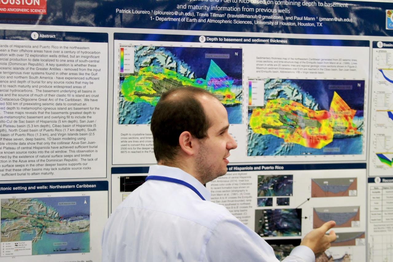
Hydrocarbon Potential of Hispaniola and Puerto Rico Based on Combining Depth to Basement and Maturity Information from Previous Wells
AUTHORS: Patrick Loureiro, Travis Tillman, and Paul Mann
ABSTRACT: The islands of Hispaniola and Puerto Rico, in northeastern Caribbean and their offshore areas, have over century of hydrocarbon exploration
with over 72 exploration wells drilled. Even so, to date an insignificant commercial production is localized to one area of south-central Hispaniola (Dominican
Republic). A key question is whether these large oceanic islands of the Greater Antilles, removed from the input of large terrigenous river systems found in
other areas like the Gulf of Mexico and northern South America, have experienced sufficient subsidence and depth of burial for any source rocks that may be
present to reach maturity and produce widespread areas of commercial hydrocarbons. The basement underlying all basins in the area and the source of much of
their clastic fill is island arc crust of the Cretaceous-Oligocene Great Arc of the Caribbean. We have compiled 500 km of preexisting seismic data to construct
an improved depth to igneous-metamorphic island arc basement for the region. These maps reveal that the basements' greatest depth to igneous-metamorphic
basement and overlying fill include the Enriquillo–Cul de Sac Basin of Hispaniola (5 km depth), San Juan/Central Plateau Basin (5.3 km depth), Cibao Basin
of Hispaniola (5 km depth), North Coast Basin of Puerto Rico (1.7 km depth), South Coast Basin of Puerto Rico (1.3 km depth), and the Virgin Islands Basin
(2.5 km depth). Of these seven deep basins, 1D basin modeling using available vitrinite data show that only the co-linear Azua–San Juan-Central Plateau of
central Hispaniola have achieved sufficient burial to place known source rocks into the oil window. This observation is supported by the existence of natural
surface seeps and limited production in the Azua area of the Dominican Republic. The lack of known surface seeps in the other deeper basins supports our
proposal that these other basins may lack suitable source rocks and/or sufficient burial to attain maturity.
- TITLE:
New Insights into the Mesozoic Evolution of the Gulf of Mexico Basin from Gravity and Deep-Penetration Seismic Reflection Data
AUTHORS: Paul Mann
ABSTRACT: I review opening models for the Gulf of Mexico (GOM) in light of our own studies of deep-penetration seismic reflection data in the eastern GOM. Most groups agree that the first phase of syn-rift GOM opening is late Triassic to early Jurassic (235 to 174 Ma) in age, northwest to southeast in extension direction, and responsible for creating a broad zone of thinned, continental crust along the northern margin of the GOM and underlying the northern salt basins of Texas, Louisiana, and Mississippi. This Late Triassic to early Jurassic rift zone is an along-strike continuation of Triassic rifts present along the eastern margin of North America. However, in the northern GOM case the rift failed to culminate in production of a parallel and contiguous zone of oceanic crust across the broad northern GOM. Progress has been slow in understanding the early history and crustal structure of this area in the GOM, due to the obscuring presence of an overlying sag basin of post-early Jurassic age filled by 3–4 km of depositional salt (now remobilized). The second and much better understood phase of GOM opening, is late Jurassic (156 to 145 Ma) and post-salt in age, and formed a large expanse of salt-free, Jurassic oceanic crust underlying the deepwater GOM shared by the U.S., Mexico, and Cuba. This second late Jurassic opening phase occurred along a highly arcuate slow spreading ridge, now well imaged on basin-wide satellite gravity maps. We have georeferenced our grid of deep-penetration seismic and well data in the eastern GOM, along with recent refraction studies to both ground-truth these satellite images and provide details of the early breakup and separation. Our eastern and northeastern GOM continent-oceanic boundary, defined by deep seismic profiles is within 20 km of that inferred from satellite gravity. We have used the shape of the satellite-imaged fracture zones in the Mexican GOM to improve the pole position for this second phase of GOM opening, which is located in the Straits of Florida. This pole restores trends of crustal fabric in Florida and the Yucatan Peninsula seen on gravity and magnetic maps to pre-rotation parallelism. We use this pole to create a kinematic plate model for the second phase of GOM opening that respects all available seismic reflection, refraction, well, and satellite imagery.
- TITLE:
What Lies beneath the Tip of the Iceberg? Late Cretaceous to Recent Tectonic Evolution of Jamaica and the Nicaraguan Rise with Implications for a Widespread Eocene Petroleum System
AUTHORS: Bryan Ott and Paul Mann
ABSTRACT: The Caribbean island of Jamaica (~11,500 km2) rises over 2.2 km above sea level at the eastern end of the much larger and shallowly submerged Nicaraguan Rise (~500,000 km2) in the western Caribbean. Upper Cretaceous to Miocene rocks exposed on land record a complex tectonic history that may have also affected the adjacent Nicaraguan Rise, is now submerged and covered by up to 2.5 km of shallow carbonate banks that form a challenging barrier for both seismic imaging and drilling. This study combines 10,000 km of 2D seismic reflection data, as well as 13 onshore and offshore wells with previous onland studies to define four tectonic phases affecting the Nicaraguan Rise that are compared to those events known from Jamaica. These events include: (1) Late Cretaceous to Paleocene arc-continent collision that resulted in transverse intra-arc rifting; these rifts are now exposed on land in a NW to SE orientation; (2) Paleocene-Eocene transtension that resulted in the formation of the Walton Basin at the boundary between the Nicaraguan Rise and Jamaica; this E–W basin is the deformed, eastern equivalent of the Honduran borderlands at the western end of the Nicaraguan Rise; (3) an Eocene- to late Miocene post-rift thermal sag phase; this subsidence event followed the opening of the Cayman Trough and marks the beginning of widespread carbonate growth on the Nicaraguan Rise; and 3) late Miocene to Recent uplift and inversion related to E–W strike-slip faulting. Previous work has shown widespread Eocene type II and III source rocks of the Chapelton Formation of Jamaica and its offshore equivalents on the Nicaraguan Rise; that are immature where encountered in wells onland, but may be mature in the deeper buried areas of the Nicaraguan Rise, including the Walton Basin.
- TITLE:
Cenozoic Structural, Deformational, and Erosional Events Observed Along a 400-km Long, Onshore-to-Offshore Regional Transect Across Northwestern South America
AUTHORS: Carlos Sanchez, Paul Mann, and Rocio Bernal
ABSTRACT: The complex Jurassic to recent tectonic evolution of northwestern South America (NSA) controlled the regional structure and formation of
differing basin types. We integrate offshore and onshore 2D seismic profiles, gravity, and magnetic grids to identify the main Cenozoic deformational stages,
associated structures and syn-tectonic basinal deposits. Two different provinces are crossed by a 400-km-long regional, onshore-to-offshore, structural
transect: (1) The offshore South Caribbean deformed belt (SCDB) and (2) the onshore Cesar-Rancheria basin (CRB). The SCDB is a 100-km-wide, late Cenozoic,
5–18 km thick, sedimentary accretionary prism formed by subduction of the Caribbean plate beneath northern South America. Key relationships seen on the offshore
part of the transect include: (1) onlapping stratal termination of an Oligocene-Miocene sequence above the subducting Caribbean plate that we interpret as a
flexure produced by the initial subduction of the Caribbean plate; and (2) Plio-Pleistocene growth strata in piggyback basins overlying the prism interpreted
as filled from the erosion of the uplifted Santa Marta massif (SMM), and from the deposition of the Magdalena submarine fan.
Key relationships seen on the onshore part of the transect crossing the SSM to the west and the Sierra de Perija to the east include two northwest-southeast
shortening events: (1) An early-middle Eocene event that produced east-dipping Cretaceous and Paleocene strata beneath a major unconformity that increases
in erosional hiatus from east to west. This shortening and overlying unconformity are interpreted as the result of collision of the Caribbean arc with South
America. (2) A late Miocene–Pliocene event with major exhumation of the eastern CRB, where recent deposits are faulted as a result of the Late Miocene to
Recent Panama arc collision. The most recent shortening event recorded in the CRB initiated the erosional event observed to the northwest in the filled,
offshore piggyback basins. Faster Pliocene-Pleistocene deformation rates in the SCDB, may indicate accelerated convergence between Caribbean and South America
and are possibly linked to the collision of the Panama arc.
|